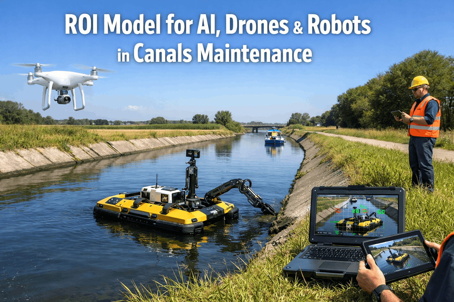
ROI Model for AI, Drones & Robots in Canals Maintenance
By Taylor on February 17, 2026
Canal networks are the arteries of water management infrastructure — delivering irrigation, flood control, hydropower, navigation, and drinking water across thousands of miles that most citizens never see. In the United States alone, over 80,000 miles of irrigation canals, flood control channels, and navigation waterways operate under the oversight of public agencies, water districts, and the U.S. Bureau of Reclamation. The problem: most of this infrastructure was built 50-100 years ago, inspection budgets have not kept pace with deterioration, and traditional manual survey methods cannot cover the scale, frequency, or depth of monitoring these assets demand. In 2026, the convergence of artificial intelligence, autonomous drones, and quadruped robots is making it economically viable for canal agencies to inspect more, detect earlier, and repair smarter than ever before. But technology adoption requires proving the numbers. This guide provides the complete ROI model for deploying AI, drones, and robots in canal maintenance — from inspection cost reduction to failure prevention savings, with documented payback timelines that justify investment to boards, councils, and federal grant reviewers. Start with Oxmaint for free and see the difference AI-powered canal inspection makes for your agency.
The Real Cost of Failing Canal Infrastructure
Before building an ROI model, it helps to understand what is at stake. The numbers behind deferred canal maintenance are staggering — and they compound every year that inspection frequency falls below the rate of deterioration. Here is what agencies without modern inspection technology face every season.
$18B
repair backlog
Estimated U.S. canal and waterway infrastructure maintenance backlog growing annually
60%
inspection gap
Percentage of canal miles overdue for comprehensive condition assessment nationwide
3-8x
ROI multiple
Documented return on AI + drone + robot canal inspection programs within 24 months
These are not edge cases. They represent the daily reality for agencies operating ageing canal networks without modern inspection technology. The good news: agencies deploying drone + robot + AI inspection programs report 40-65% lower inspection costs, 70% faster defect identification, and dramatically improved safety for field crews working along unstable embankments, confined structures, and remote corridors. Book a demo with Oxmaint to see how these savings apply to your specific canal portfolio.
What Drives ROI in Technology-Enabled Canal Maintenance
Not every technology investment delivers returns. Many agencies have purchased drones or sensors only to discover that raw data without AI analytics, CMMS integration, or prioritisation logic creates more confusion than clarity. When building an ROI model for canal maintenance technology, these are the value drivers that separate proven returns from expensive experiments.
Inspection Savings
40-65% Lower Per-Mile Inspection Cost
Drones survey canal embankments, linings, structures, and rights-of-way in hours instead of days. Robots inspect confined spaces — siphons, tunnels, culverts, and check structures — without dewatering or confined-space entry teams.
Failure Prevention
Avoid $2M-$50M Canal Breach Events
AI-powered defect detection identifies seepage, erosion, lining deterioration, and embankment instability before catastrophic failure. A single avoided breach saves more than the entire multi-year technology investment.
Coverage Multiplier
5-10x More Miles Inspected Per Season
Drone + robot programs cover 5-10x more canal miles per inspection budget dollar than manual walking surveys. This means agencies finally achieve the inspection frequency their assets require — not just the frequency they can afford.
Labour Reallocation
Redirect Crews to Repair, Not Survey
When drones and robots handle data collection, skilled maintenance crews spend 100% of their time on repairs and capital projects — the work that actually extends asset life — instead of walking miles with clipboards.
Safety Elimination
Zero-Exposure Hazardous Inspections
Eliminate confined-space entries into siphons and tunnels, unstable embankment traversals, and drowning-risk waterside surveys. Each avoided safety incident eliminates injury costs, insurance claims, and OSHA liability.
Grant Advantage
Data-Backed Federal Funding Applications
AI-generated condition data, deterioration trending, and documented maintenance costs give agencies the quantified evidence that BIL and WaterSMART grant applications require — lifting win rates from 12% to 45%+.
Oxmaint integrates drone data, robot inspections, IoT sensors, and AI analytics into one platform built for canal and waterway agencies. See why water districts and irrigation authorities choose Oxmaint to automate canal maintenance.
Head-to-Head: Top AI, Drone & Robot Platforms for Canal Maintenance 2026
We evaluated the most capable platforms across the criteria that matter to public water agencies: AI defect detection for canal-specific assets, drone and robot payload flexibility, CMMS integration depth, grant documentation support, and total cost of deployment. Here is an honest comparison to help you shortlist the right fit for your canal network.
Recommended
Oxmaint AI
Water districts, irrigation agencies, and canal authorities
Full drone + robot to CMMS canal inspection pipelineFree tier available — no procurement barriers
Aerial survey and thermal imaging fleet operations
Industry-leading drone hardware reliabilityThermal + multispectral payload options for seepageFlightHub 2 fleet management and mapping tools
Hardware + subscription model
Boston Dynamics Spot
Embankment and structure inspection in difficult terrain
All-terrain quadruped navigation along canal banksAutonomous patrol with thermal and visual payloadsConfined-space inspection of tunnels and siphons
Robot lease + software licensing
Skydio X10
Autonomous inspection in GPS-denied canal structures
Best-in-class autonomous obstacle avoidance3D Scan for repeatable canal structure digital twinsExcels in confined and GPS-denied environments
Enterprise pricing
Flyability ELIOS 3
Confined-space siphon and tunnel interior inspections
Caged drone designed for enclosed space inspectionLiDAR mapping in complete darkness underwater tunnelsEliminates confined-space entry and dewatering need
Hardware + software licensing
Pix4D + DroneDeploy
Photogrammetry mapping and embankment volumetrics
Survey-grade orthomosaics and elevation modelsEmbankment erosion volumetric measurement toolsIntegration with GIS for spatial asset management
~$350-500/month per user
Platform capabilities reflect publicly available data as of early 2026. Every agency's canal network and risk profile is different — the best way to evaluate is hands-on. Create a free Oxmaint account and run it alongside your current inspection process to see real results on your canal assets.
Why Oxmaint Wins for Canal and Waterway Agencies
Plenty of platforms capture impressive aerial imagery of canal corridors. The real test is whether that data reaches the right maintenance crew, generates an actionable work order, produces the condition documentation your board and federal funders require, and proves the ROI that justifies continued investment — automatically. Oxmaint is built around one principle: inspection data is worthless unless it drives repair decisions and documents savings.
Drone & Robot Data to Work Orders in Minutes
AI processes drone and robot imagery on ingest, identifies canal-specific defects — lining cracks, seepage zones, erosion, vegetation encroachment, structural spalling — classifies severity, and auto-generates CMMS work orders with GPS coordinates, photos, and recommended repair actions. No manual image review. No data re-entry.
Multi-Asset Coverage Across Your Canal Network
One platform manages inspections for canal linings, embankments, check structures, siphons, tunnels, diversion dams, spillways, gates, culverts, and right-of-way encroachments — every asset type in your canal portfolio tracked with full history, condition trending, and scheduled re-inspection alerts.
Mobile Field Access for Canal Crews
Maintenance crews receive work orders on their phones with exact defect locations along the canal, severity photos, and repair specifications. Offline mode ensures functionality in remote canal corridors and areas without cell coverage — critical for irrigation district field teams working miles from the nearest road.
ROI Dashboards for Board and Grant Reporting
Track documented cost savings, inspection coverage improvement, defect detection rates, and repair completion metrics in real-time. Generate board-ready reports and federal grant documentation that proves technology investment ROI with auditable data — not estimates. Sign up for Oxmaint to explore live ROI tracking dashboards.
Before & After: What Changes With AI, Drone & Robot Canal Inspections
The shift from manual canal inspection programmes to technology-powered monitoring is not incremental — it is transformational. Here is what that transition looks like in practice for a typical irrigation district, water authority, or flood control agency.
Traditional Canal Inspections
Walking surveys covering 2-5 miles per crew per day along embankments
Confined-space entry teams for siphon, tunnel, and culvert inspections
Paper and spreadsheet reports filed weeks after inspection with no trending
Seepage and erosion detected only when visible at surface level
Grant applications lacking quantified condition data and cost justification
$3,200+
average cost per canal mile using traditional walking survey methods
AI + Drone + Robot Inspections
Drone surveys covering 15-30 miles per day with thermal and multispectral imaging
Robots inspect confined structures without dewatering or confined-space entry
AI-analysed reports with CMMS work orders generated same day
Thermal imaging detects subsurface seepage before embankment failure
Automated condition reports provide data-driven grant application evidence
40-65%
reduction in per-mile inspection costs with 5-10x coverage improvement
Modernize your canal inspection programme without the risk. Oxmaint's free tier lets you run a real pilot on your canal assets — no procurement cycle, no contracts, no consultant fees.
The ROI Numbers: Documented Returns From Canal Technology Programs
Board members, district managers, and federal grant reviewers need hard numbers to justify technology investment. The evidence from early-adopter water districts and canal authorities is clear — agencies that deploy integrated AI, drone, and robot inspection programmes see measurable returns across multiple dimensions within the first 12-24 months.
65%
Lower Inspection Costs
Versus traditional walking survey and confined-space entry methods
70%
Faster Defect Detection
AI identifies seepage, erosion, and lining damage in hours, not weeks
90%
Reduced Safety Exposure
Near-total elimination of confined-space entry and unstable bank traversals
3-8x
ROI Multiple
Documented return when breach avoidance savings are included in the model
These improvements compound over time as AI models learn your canal network's deterioration patterns and your teams build data-driven maintenance strategies. Create your free Oxmaint account and start tracking canal condition metrics within the first 30 days.
Your 4-Step Path to Proving Technology ROI
Building an AI, drone, and robot inspection programme should not take years of pilot studies and consultant reports. Use this streamlined framework to go from evaluation to documented ROI in months, not budget cycles.
1
Baseline Your Current Inspection Costs
Document what you spend today: per-mile survey costs, confined-space entry expenses, staff hours per inspection cycle, report preparation time, and emergency repair costs from undetected failures. This baseline is the denominator of your ROI equation — without it, you cannot prove savings.
2
Pilot on 10-20 Miles of High-Risk Canal
Run drone surveys with AI analysis and robot inspections on your highest-risk canal segments — the reaches with known seepage, oldest linings, or most critical water delivery obligations. Compare defect detection rates, cost per mile, and reporting speed against your baseline using real data.
3
Document Savings and Validate Findings
Confirm AI-detected defects against field verification. Calculate actual cost savings versus baseline. Document inspection coverage improvement, safety exposure reduction, and time savings. Build the ROI case with auditable numbers — not projections.
4
Scale Across Your Network and Apply for Grants
Once proven, expand to your full canal portfolio. Use documented condition data for BIL and WaterSMART grant applications. Integrate IoT sensor data for continuous monitoring between drone flights. Present auditable ROI to your board to secure ongoing technology investment. Schedule a walkthrough to plan your agency's rollout.
The agencies that will lead the next decade of canal infrastructure management are the ones proving technology ROI with documented savings today. We showed our board a 5x return in year one — combining inspection cost reduction with a single avoided embankment failure that would have cost $8M in emergency repairs and water delivery interruption. The technology paid for itself before the first season ended.
Operations Director, Western Irrigation District
Your Ratepayers Deserve Canal Infrastructure That Is Inspected, Not Neglected
Oxmaint brings together drone survey data, robot inspection findings, IoT sensor streams, AI defect detection, and automated CMMS work orders in one platform built for canal agencies. Survey embankments without walking every mile, inspect siphons without confined-space entry, detect seepage before embankment failure, and give your maintenance crews the actionable data they need — with documented ROI that justifies every dollar invested.
How do drones inspect canal embankments and linings effectively?
Fixed-wing and multi-rotor drones equipped with high-resolution visual, thermal, multispectral, and LiDAR sensors survey canal corridors at speeds of 15-30 miles per day. Thermal imaging detects subsurface seepage through temperature differentials in embankment surfaces. Multispectral cameras identify vegetation stress patterns that indicate moisture infiltration. LiDAR generates precise elevation models that reveal erosion, settlement, and deformation invisible to the naked eye. Oxmaint's AI processes all sensor data on ingest, classifying canal-specific defects and auto-generating geo-tagged work orders with repair recommendations. Sign up for Oxmaint to explore the canal defect classification library.
Can robots really replace confined-space entry for siphon and tunnel inspections?
Yes — and this is often the single largest safety and cost driver in canal ROI models. Quadruped robots (Boston Dynamics Spot) and caged drones (Flyability ELIOS 3) inspect siphons, tunnels, culverts, and check structures without dewatering, confined-space entry teams, or rescue standby crews. Robot inspections capture the same visual, thermal, and structural data as human entries — often with higher consistency and repeatability. A single confined-space inspection that costs $8,000-$15,000 with traditional methods can be completed for $2,000-$5,000 with robotic inspection.
What types of canal defects can AI detect from drone and robot imagery?
Current AI models trained for canal infrastructure detect and classify: concrete lining cracks and spalling, gunite deterioration, earthen embankment erosion and settlement, seepage and piping indicators via thermal anomaly, vegetation encroachment, right-of-way encroachments, structural concrete deterioration in check structures and siphon portals, gate and operating mechanism corrosion, and sediment accumulation. Thermal sensors detect subsurface moisture movement that visual inspection cannot identify — often the earliest indicator of pending embankment failure. Schedule a demo to see canal-specific AI defect detection in action.
How do we calculate ROI to present to our board or grant application?
A defensible canal technology ROI model includes four components: (1) inspection cost savings — baseline per-mile cost minus technology per-mile cost multiplied by total miles, (2) failure avoidance value — probability-weighted cost of breach events that improved detection prevents, (3) labour reallocation value — crew hours redirected from survey to repair at loaded labour rates, and (4) safety incident avoidance — actuarial value of eliminated confined-space entries and hazardous exposures. Oxmaint automatically generates ROI reports tracking actual versus baseline costs, documented savings per inspection cycle, and cumulative programme return — giving your board and federal grant reviewers the auditable numbers they require.
What is the payback timeline for a canal AI, drone, and robot programme?
Most agencies see measurable cost savings within the first inspection season. A canal district inspecting 200 miles annually at $3,200 per mile ($640,000/year) can reduce costs to $1,200-$1,800 per mile with drone + AI methods — saving $280,000-$400,000 annually. When failure avoidance is included (a single avoided breach event worth $2M-$50M), the ROI multiple jumps to 3-8x within 24 months. Additional value comes from eliminated confined-space entry costs ($8K-$15K per structure), reduced safety liability, and improved grant competitiveness through documented condition data. Book a demo to build a projected ROI model for your specific canal network.